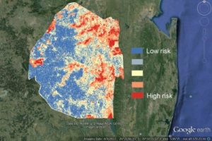
UC San Francisco (UCSF) is working to create an online platform that health workers around the world can use to predict where malaria is likely to be transmitted using data on Google Earth Engine.

The goal is to enable resource poor countries to wage more targeted and effective campaigns against the mosquito-borne disease, which kills 600,000 people a year, most of them children.
Faced with a multitude of public health needs, countries often make the mistake of cutting their malaria efforts just when they are close to eliminating the disease, said Hugh Sturrock, PhD, MSc, an assistant professor of epidemiology and biostatistics and a researcher in the Global Health Group, which is a part of UCSF’s Global Health Sciences.
“This can have disastrous consequences, since malaria can quickly rebound, putting years of expensive control efforts to waste,” he said. “But with these maps, health workers will know exactly where to target their scarce resources. That way, they can keep fighting the disease until it’s eliminated within their borders.”
Google Earth Engine brings together the world’s satellite imagery — trillions of scientific measurements dating back almost 40 years — and makes it available online with tools for scientists, independent researchers and nations to mine this massive warehouse of data to detect changes, map trends and quantify differences on the Earth’s surface.

